






In an era defined by digital ephemera, satellite navigation, and fleeting algorithmic feeds, the tactile endurance of cartography continues to hold a profound, grounding appeal. Nowhere is this more evident than in the enduring popularity of the official World Heritage Map, a flagship cartographic publication released periodically by the United Nations Educational, Scientific and Cultural Organization (UNESCO).
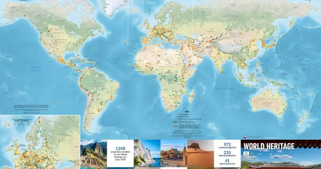
The latest edition of this landmark publication is now officially available to order, offering a breathtaking visual compendium of human achievement and natural wonder. Measuring poster-sized and meticulously detailed, this year’s iteration catalogues an unprecedented 1,248 World Heritage properties spanning 168 States Parties. More than a mere navigational tool, the map functions as an ideological and cultural manifesto, capturing the fragile beauty of our planet’s most universally significant landscapes and monuments through stunning, high-resolution photography and rigorous geographical data.
At the epicenter of this year’s design is a striking featured image: the Jongmyo Shrine of the Republic of Korea. Chosen for its peerless historical authenticity and architectural harmony, the Confucian royal sanctuary represents the pinnacle of ancestral veneration and intangible heritage preservation.
Produced through an enduring collaboration between the UNESCO World Heritage Centre and cartographic publisher Geo4Map—with the generous financial and logistical support of the Republic of Korea—the map serves a dual purpose. It is simultaneously an educational resource for classrooms and libraries worldwide, and a stark, beautiful reminder of the collective responsibility humanity shares in safeguarding these irreplaceable sites against the relentless pressures of climate change, mass tourism, and geopolitical conflict.
Detailed Chronology: The Evolution of Cartography at UNESCO
To fully appreciate the significance of the latest World Heritage Map, one must trace the historical convergence of global cartography, international diplomacy, and heritage conservation over the past half-century.
The Genesis of the Convention (1972–1975)
The architecture of the World Heritage list was established on November 16, 1972, when the General Conference of UNESCO adopted the Convention Concerning the Protection of the World Cultural and Natural Heritage. The foundational premise was revolutionary: certain places on Earth possess an "outstanding universal value" so exceptional that their conservation is the concern of all humanity, transcending national boundaries.
However, in the pre-digital era of the 1970s, communicating the scope of this global endeavor presented a formidable logistical challenge. How could disparate populations in disparate hemispheres conceptualize a unified global network of protected sites? The answer lay in visual cartography. Early inventories were largely textual, bound in dense bureaucratic volumes. It quickly became apparent that visual aids were essential not only for administrative oversight by the World Heritage Committee but also for public engagement and international solidarity.
The Transition to Public-Facing Posters (1980s–1990s)
Throughout the 1980s, as the list expanded to include iconic landmarks like the Great Barrier Reef, the historic center of Rome, and Yellowstone National Park, UNESCO began experimenting with large-format educational posters. These early maps were rudimentary by modern standards—often relying on hand-drawn cartography, basic vector outlines, and limited color palettes. Yet, they laid the psychological groundwork for the modern wall map. They hung in geography classrooms, diplomatic offices, and museum foyers, silently preaching the gospel of international preservation.
By the turn of the millennium, the rapid democratization of Geographic Information Systems (GIS) and digital printing technology revolutionized the production cycle. The map transformed from a static reference chart into an artistic and educational masterpiece. High-definition satellite data merged with vivid, ground-level architectural and ecological photography, turning the map into a coveted collector’s item for educators, travelers, and geography enthusiasts alike.
The Modern Era and the Milestone of 1,248 Properties
In recent years, the acceleration of inscriptions has drastically increased the complexity of cartographic design. Every year, during the extended sessions of the World Heritage Committee, new natural, cultural, and mixed properties are added to the roster, testing the limits of physical map design.
The current edition—featuring an astonishing 1,248 properties—represents a monumental achievement in data visualization. Squeezing nearly twelve hundred and fifty distinct geographical points, accompanied by descriptive captions, national borders, and marine boundaries onto a single poster-sized sheet without sacrificing legibility requires cutting-edge cartographic engineering. The partnership with Geo4Map, established in recent cycles, has ensured that every iteration achieves millimeter-precise accuracy while maintaining the striking aesthetic standards expected of a United Nations publication.
Supporting Context & Metrics: The Anatomy of Global Heritage
The release of the new wall map is not merely an aesthetic event; it is an opportunity to analyze the quantitative and qualitative distribution of global heritage through rigorous statistical lenses.
The Geographic and Typological Breakdown
The 1,248 properties catalogued on the map are distributed across 168 countries, reflecting a massive global commitment to preservation, though significant regional and categorical disparities remain.
- Cultural Properties: Representing the vast majority of the list, these include archaeological sites, historic cities, monumental architecture, and cultural landscapes. They bear witness to human ingenuity, artistic expression, and the evolution of civilizations over millennia.
- Natural Properties: These encompass outstanding geological formations, ecological and biological systems, and natural habitats threatened by extinction. They serve as the Earth’s life support systems and scientific laboratories.
- Mixed Properties: A smaller, highly select category of sites that satisfy both cultural and natural criteria, such as Peru’s historic sanctuary of Machu Picchu or Australia’s Tasmanian Wilderness.
| Region | Approximate Percentage of Total Sites | Notable Focus Areas |
|---|---|---|
| Europe & North America | ~46% | High concentration of historic urban centers, industrial heritage, and early-industrial architectural monuments. |
| Asia & the Pacific | ~26% | Rapidly growing sector featuring ancient royal capitals, sacred mountains, and extensive biodiversity hotspots. |
| Latin America & the Caribbean | ~14% | Pre-Columbian archaeological wonders, colonial grid cities, and vast neotropical rainforests. |
| Africa | ~9% | Cradle of humankind sites, monumental trans-boundary wildlife parks, and ancient trading cities. |
| Arab States | ~5% | Desert caravan routes, ancient Nabatean rock-cut architecture, and remarkably preserved medieval Islamic medinas. |
The Cartographic Challenge: Scale vs. Detail
Designing the 2024–2025 wall map required resolving an eternal cartographic dilemma: how to represent densely packed regions (such as Western Europe or parts of East Asia) alongside vast, sparsely populated expanses (such as the high Arctic or central Sahara).
To solve this, Geo4Map employed sophisticated inset scaling and optimized marker placements. Each of the 1,248 properties is designated by a precise coordinate dot, cross-referenced with an index that details its year of inscription and classification type. The integration of high-resolution photographic vignettes around the map’s border acts as visual anchor points, drawing the viewer’s eye from the macro-level view of global geopolitics down to the micro-level textures of stone, wood, water, and earth.
Spotlight on the Jongmyo Shrine: A Masterpiece of Intangible Continuity
Every edition of the World Heritage Map features a carefully curated hero image that sets the thematic tone for the publication. For this year’s edition, the spotlight falls squarely upon the Jongmyo Shrine in the Republic of Korea—a profound selection that honors not only physical architecture, but the living traditions that inhabit it.
Historical Foundations and Architecture
Located in the heart of Seoul, the Jongmyo Shrine is the oldest and most authentic of the Confucian royal shrines preserved today. Constructed in 1394 under the visionary guidance of King Taejo, the founder of the Joseon dynasty, the shrine was designed to enshrine the spirit tablets of former kings and queens.
Architecturally, Jongmyo is a masterclass in austere, solemn dignity. Unlike the brightly painted, ornate Buddhist temples characteristic of the era, the main shrine buildings (Jeonjeon and Nyeongnyeongjeon) are defined by their long, low, unadorned wooden facades. This minimalist aesthetic was deliberately chosen to reflect Confucian ideals of piety, solemnity, and restraint. The vast, paved stone courtyard (Nandang) stretches before the buildings, creating a cavernous space designed to accommodate the grand, solemn processions and ritual choreography of the royal court.
The Living Heritage of Jongmyo Jerye
What elevates the Jongmyo Shrine from an impressive historical relic to an absolute masterpiece of global heritage is the unbroken continuity of its ritual practices.
For over six centuries, the Jongmyo Jerye (royal ancestral ritual) and its accompanying Jongmyo Jeryeak (ritual music and dance) have been performed continuously. These ceremonies are not hollow theatrical reenactments; they are living manifestations of ancestral veneration, filial piety, and cosmic harmony deeply embedded in Korean cultural memory. In 2001, UNESCO recognized the extraordinary nature of this living tradition by proclaiming the Jongmyo Jerye and Jongmyo Jeryeak as Masterpieces of the Oral and Intangible Heritage of Humanity, later incorporating them into the Representative List of the Intangible Cultural Heritage of Humanity.
By placing the Jongmyo Shrine on the cover of the World Heritage Map, UNESCO sends a powerful theoretical message: heritage is not merely about dead stone and static monuments. It is about the unbroken thread of human memory, ritual, and community that breathes life into physical spaces across generations.
Official Statements and Institutional Collaboration
The realization of the 2024–2025 World Heritage Map is the product of profound institutional synergy, reflecting a shared international commitment to cultural diplomacy and public education.
The Vision of the World Heritage Centre
In statements accompanying the launch, representatives from the UNESCO World Heritage Centre emphasized the pedagogical and diplomatic utility of the map.
"In an increasingly fragmented world, the World Heritage Map serves as a powerful visual testament to our shared human story," noted a senior communications official at the Centre. "When a student, a diplomat, or a traveler looks at this map, they do not see isolated national territories; they see a connected constellation of human creativity and natural wonder. It reminds us that the preservation of the Taj Mahal, the Galapagos Islands, or the Jongmyo Shrine is a duty shared by every citizen of the global community."
The Contribution of the Republic of Korea
The Republic of Korea’s financial and logistical backing of this year’s cartographic project underscores the nation’s longstanding role as a champion of international cultural cooperation. As a member of the World Heritage Committee and a custodian of numerous world-class heritage sites—ranging from the volcanic island and lava tubes of Jeju to the historic villages of Hahoe and Yangdong—South Korea has consistently punched above its weight in supporting UNESCO’s global mandate.
Korean cultural authorities noted that featuring the Jongmyo Shrine highlights the nation’s unique capacity to bridge ancient spiritual traditions with modern technological and administrative preservation standards. The partnership with Geo4Map further demonstrates how private-sector cartographic expertise can be harnessed to serve public-interest diplomacy.
Future Outlook: Cartography in the Age of Digital Heritage
As the ink dries on the latest physical printing of the World Heritage Map, cartographers, conservationists, and international policymakers are already looking toward the horizon. The future of heritage mapping is poised at a fascinating intersection between tactile tradition and digital immersion.
The Digital Frontier: GIS, 3D Modeling, and Open Data
While the physical wall map remains an indispensable educational poster, the underlying data infrastructure managed by UNESCO and partners like Geo4Map is becoming increasingly digital, dynamic, and interconnected.
Looking forward, the integration of Geographic Information Systems (GIS) with real-time satellite monitoring is revolutionizing how heritage sites are protected. Climate change, deforestation, urban encroachment, and armed conflict pose existential threats to properties across the globe. Digital mapping initiatives are now moving beyond static coordinates to incorporate:
- Real-time climate risk modeling: Tracking sea-level rise around coastal World Heritage cities and glacial retreat in high-altitude natural sites.
- High-resolution 3D photogrammetry: Creating sub-millimeter digital twins of vulnerable monuments, ensuring that even if physical destruction occurs, architectural data is preserved for future reconstruction.
- Interactive web portals: Allowing students and researchers anywhere in the world to click on a point on a digital replica of the wall map and instantly access high-resolution archival documents, oral history recordings, and live environmental telemetry.
The Enduring Power of the Wall Map
Despite these dazzling technological horizons, the physical wall map retains a unique psychological power that glowing screens cannot replicate. The expansive scale of a poster-sized map invites contemplation, spatial awareness, and serendipitous discovery in a way that algorithmic scrolling never can.
As the international community grapples with the mounting challenges of the 21st century—from the existential threat of climate change to the erosion of cultural identity—tools like the UNESCO World Heritage Map remain vital anchors. They remind us of what is at stake, where we have been, and what we have inherited from the deep corridors of time.
How to Order
The latest edition of the World Heritage Map is available now for educators, institutions, researchers, and global citizens. Orders can be placed directly through the official UNESCO World Heritage Centre website. Whether mounted in a university lecture hall, a municipal boardroom, or a child’s bedroom, the map stands as an inspiring invitation to explore, understand, and protect the magnificent diversity of our shared planetary home.