








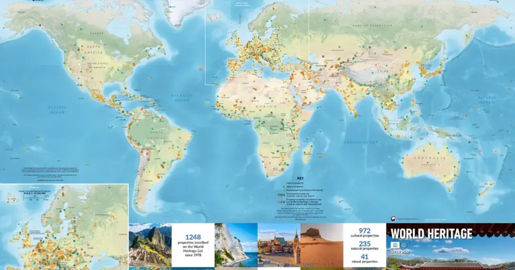
PARIS — In an era marked by digital transience, rapid-fire imagery, and hyper-fragmented media consumption, the tangible geography of human achievement and planetary wonder has just been given a striking new anchor. The UNESCO World Heritage Centre, in strategic partnership with cartographic specialists Geo4Map and with the generous financial and diplomatic backing of the Government of the Republic of Korea, has officially announced the release and immediate availability of the latest edition of the World Heritage Map.
Far more than a simple navigational tool or a decorative wall hanging, this newly minted, poster-sized cartographic publication serves as a sweeping visual census of the Earth’s irreplaceable cultural and natural treasures. It documents a meticulously curated universe of exactly 1,248 designated properties spread across 168 States Parties. Featuring high-definition photography, geopolitical boundary data, and analytical metrics, the map bridges the gap between high-altitude global governance and localized preservation efforts, offering educators, researchers, policymakers, and global citizens a panoramic window into the shared legacy of humankind.
Executive Overview: Cartography as a Tool for Global Stewardship
At its core, the newly released World Heritage Map is an exercise in geopolitical storytelling and visual diplomacy. Every iteration of the map acts as a living snapshot of the ever-expanding 1972 Convention Concerning the Protection of the World Cultural and Natural Heritage—a foundational international treaty that codified the principle that certain places on Earth are of "outstanding universal value" and belong to the collective heritage of all humanity.
The latest edition distills the monumental scope of the World Heritage List into a single, cohesive masterwork. Spanning continents, oceans, deep-sea trenches, and remote mountain peaks, the map plots all 1,248 designated sites. It balances cultural landmarks—such as sprawling archaeological ruins, medieval cityscapes, industrial heritage sites, and sacred architectural complexes—with natural phenomena, including biodiverse national parks, geological wonders, and critical marine reserves, alongside a select category of mixed sites that fulfill both cultural and natural criteria.
Beyond its aesthetic appeal, the executive significance of this publication lies in its pedagogical and awareness-raising power. In an age where climate change, armed conflict, mass tourism, and urban encroachment threaten the physical integrity of humanity’s most treasured sites, the map acts as an accessible, omnipresent reminder of what is at stake. By mapping these locations side by side—erasing artificial political borders in favor of a unified mosaic of global heritage—UNESCO underscores the interconnected destiny of civilizations past, present, and future.
Detailed Chronology: From the 1972 Convention to the 1,248-Site Milestone
To fully understand the weight of the new World Heritage Map, one must trace the evolutionary arc of the international conservation movement over the past half-century. The journey from a fledgling conservation ideal to a globally recognized institutional powerhouse is marked by pivotal historical milestones.
1959–1965: The Nubian Monuments Campaign and the Genesis of International Solidarity
The intellectual genesis of the World Heritage concept can be traced directly to the banks of the Nile in the late 1950s. The construction of the Aswan High Dam threatened to submerge the ancient Abu Simbel temples and other invaluable monuments of Nubian civilization. In response to an urgent appeal by the governments of Egypt and Sudan, UNESCO launched an unprecedented international salvage campaign in 1959. Archaeologists, engineers, and financial donors from dozens of nations banded together to dismantle the rock-cut temples piece by piece and reassemble them on higher ground. This monumental victory proved that humanity possessed the collective capacity to rally across ideological divides to protect endangered cultural history.
1972: The Birth of the Convention
Buoyed by the success of the Nubian campaign, the International Union for Conservation of Nature (IUCN) developed proposals for a unified system combining nature conservation and the preservation of cultural properties. These efforts culminated on November 16, 1972, when the General Conference of UNESCO adopted the Convention Concerning the Protection of the World Cultural and Natural Heritage. The treaty established a dual mandate: identifying cultural and natural properties of universal value and creating an international cooperation framework to assist in their safeguarding.
1978–Present: Exponential Growth and the Evolution of Mapping
In 1978, the World Heritage Committee inscribed its first batch of 12 sites onto the List, including the Galapagos Islands, Yellowstone National Park, Rock-Art Sites of Al-Frifrea, and the historic center of Kraków. From those modest beginnings, the list has expanded exponentially through decades of rigorous evaluation by advisory bodies like ICOMOS (International Council on Monuments and Sites) and the IUCN.
As the list grew from dozens to hundreds, and eventually past the milestone of one thousand properties, the demand for visual and geographic registries grew concurrently. The World Heritage Map evolved from rudimentary, text-heavy charts into sophisticated infographics incorporating satellite data, ecological zoning, and high-fidelity photography. The current 2024–2025 edition represents the zenith of this evolutionary trajectory, synthesizing data from decades of continuous inscription committees into an intuitive, visually arresting format.
Supporting Context & Metrics: Decoding the World Heritage Landscape
To appreciate the cartographic complexity behind the new map, one must examine the underlying data architecture that defines the modern World Heritage system. The 1,248 properties illustrated on the map are not distributed evenly across the globe; rather, they reflect complex historical distributions, geopolitical negotiations, and geographical disparities that UNESCO continuously seeks to address through its "Global Strategy for a Credible, Balanced, and Representative World Heritage List."
Breakdown of the 1,248 Properties
- Cultural Properties: Representing the vast majority of inscriptions (over 900 sites), these encompass monuments, groups of buildings, and sites of historical, aesthetic, archaeological, scientific, ethnological, or anthropological significance.
- Natural Properties: Numbering over 200 sites, these cover outstanding physical, biological, and geological formations; habitats of threatened species of animals and plants; and natural sites of scientific or conservation value.
- Mixed Properties: A smaller, highly select category of roughly 40 sites that satisfy both cultural and natural criteria (e.g., Machu Picchu in Peru or mixed landscapes like Kakadu National Park in Australia).
Geographical Distribution and State Party Engagement
The map vividly illustrates the concentration of World Heritage sites across different global regions. While European and North American nations historically held a dominant share of inscriptions—owing in part to early institutional capacities and resource availability—recent decades have seen concerted efforts to elevate representation from under-represented regions, particularly across Africa, the Pacific, and the Caribbean.
Furthermore, the map highlights the rising phenomenon of Transboundary Sites—properties shared by two or more nations. Examples include the Maloti-Drakensberg Park (shared by Lesotho and South Africa) and the Uvs Nuur Basin (shared by Mongolia and the Russian Federation). These transnational inscriptions require cross-border diplomatic cooperation, ecological harmonization, and joint management frameworks, serving as laboratories for peace and regional integration.
The Cartographic Challenge: Geo4Map and the Visual Narrative
Translating this massive matrix of spatial and cultural data onto a single sheet of paper required cutting-edge cartographic techniques. Geo4Map, renowned for its precision cartography and topographic expertise, utilized advanced geographic information systems (GIS) to ensure absolute accuracy in mapping site coordinates, marine boundaries, and terrestrial buffers.
However, the map is far more than a technical blueprint; it is a visual journey. Each of the 1,248 locations is cross-referenced with essential data points, including country of location, year of inscription, and thematic classification. Surrounding the main cartographic projection are curated photographic vignettes that draw the viewer’s eye from the icy fjords of Norway’s Western Norwegian Fjords to the ancient mud-brick architecture of Timbuktu in Mali.
Spotlight on the Cover Star: The Jongmyo Shrine
Tradition dictates that every edition of the World Heritage Map features a prominent, symbolic property on its front cover to anchor the visual narrative of that release. For the 2024–2025 edition, the spotlight has been cast upon the Jongmyo Shrine in the Republic of Korea—a profound masterwork of royal architecture, spiritual continuity, and living intangible heritage.
Architectural Majesty and Confucian Philosophy
Inscribed on the UNESCO World Heritage List in 1995, the Jongmyo Shrine, located in the heart of Seoul, is the oldest and most authentic of the surviving Confucian royal shrines. Constructed in 1394 upon the founding of the Joseon dynasty, the complex was designed to enshrine the spirit tablets of former kings and queens, serving as the spiritual core of the royal court.
Architecturally, Jongmyo is celebrated for its austere elegance, restraint, and spatial harmony. The main hall, Jeongjeon, is a long, low-slung wooden structure characterized by its repetitive bays, unadorned surfaces, and profound silence. Unlike the ornate, colorful Buddhist temples of East Asia, Jongmyo reflects the strict neo-Confucian ideals of frugality, solemnity, and profound reverence for ancestry. It is widely considered a masterpiece of spatial design, where geometry and topography converge to evoke eternity and cosmic order.
Living Heritage and the Jongmyo Jerye
What elevates the Jongmyo Shrine from an exceptional architectural relic to a transcendent global treasure is the unbroken continuity of its ritual practices. For over six centuries, descendants of the royal family, scholars, and citizens have gathered at the shrine to perform the Jongmyo Jerye—an elaborate royal ancestral ritual accompanied by court music (Jongmyo Jeryeak) and ritual dance (Ilmu).
This ancient ceremony, designated by UNESCO as a Masterpiece of the Oral and Intangible Heritage of Humanity, is performed annually on the first Sunday of May. The music, played on traditional instruments such as bronze bells, stone chimes, zithers, and flutes, combined with the slow, synchronized movements of dancers holding wooden flutes and feathers, creates an immersive sensory experience that has remained virtually unchanged since the 15th century.
By featuring the Jongmyo Shrine on its cover, UNESCO highlights the inseparable link between tangible monuments and living cultural traditions. The cover serves as a reminder that World Heritage is not merely about preserving dead stones, but about safeguarding the living cultural DNA of human societies.
Official Statements and International Partnership
The realization of the 2024–2025 World Heritage Map is the culmination of a robust international partnership bridging intergovernmental diplomacy, private-sector cartographic innovation, and national cultural sponsorship.
Speaking from UNESCO Headquarters in Paris, representatives of the World Heritage Centre emphasized the critical role of multi-stakeholder collaboration in disseminating educational tools to the public.
"The World Heritage Map is much more than a geographical poster; it is a declaration of our shared global citizenship," noted a senior official from the World Heritage Centre during the release briefing. "When a student, a teacher, or a traveler looks at this map and traces their fingers across 1,248 properties spanning every corner of the globe, they are internalizing a fundamental truth: that the Great Barrier Reef, the Pyramids of Giza, the historic center of Prague, and the Jongmyo Shrine do not belong merely to the nations that house them, but to the entire human family. We extend our deepest gratitude to the Government of the Republic of Korea for their steadfast support of this initiative, and to Geo4Map for translating our complex global database into an exquisite visual masterpiece."
The financial and diplomatic backing provided by the Republic of Korea reflects the nation’s profound commitment to international cultural cooperation. As a prominent State Party to the 1972 Convention and a former member of the World Heritage Committee, South Korea has consistently championed initiatives that bridge cultural preservation with educational outreach. Korean cultural authorities noted that choosing the Jongmyo Shrine for the map’s cover is a great honor that underscores Korea’s rich historical legacy and its ongoing dedication to preserving both tangible monuments and living traditions for future generations.
Future Outlook: Challenges and Preservation in the 21st Century
As the new World Heritage Map makes its way into classrooms, libraries, research institutions, and homes across the globe, it arrives at a critical juncture for international conservation. While the map celebrates the beauty and diversity of 1,248 sites, it also serves as a silent testament to the unprecedented pressures facing these locations in the 21st century.
Climate Change as an Existential Threat
Chief among these challenges is anthropogenic climate change. Natural sites like the Great Barrier Reef are suffering from severe coral bleaching events induced by warming ocean temperatures, while glacial retreats threaten iconic mountain parks in both the Global North and South. Cultural sites are equally vulnerable; rising sea levels threaten coastal heritage cities like Venice and the ancient ruins of Tyre, while extreme weather events, prolonged droughts, and desertification endanger archaeological sites across Africa and the Middle East.
Armed Conflict and Looting
Geopolitical instability remains a persistent menace to cultural heritage. Recent conflicts in the Middle East, Eastern Europe, and parts of Africa have demonstrated the devastating vulnerability of historic cities, museums, and religious sanctuaries to targeted destruction and illicit trafficking of antiquities. UNESCO’s monitoring mechanisms, supported by satellite imagery and international legal frameworks like the 1954 Hague Convention, work tirelessly to document damage and coordinate emergency safeguarding operations.
Overtourism and Sustainable Management
Paradoxically, inclusion on the World Heritage List can sometimes be a double-edged sword. The "UNESCO effect" frequently triggers massive surges in international tourism, leading to severe overcrowding, ecological degradation, and infrastructural strain in historic centers like Dubrovnik, Venice, and Machu Picchu. Managing the delicate balance between sustainable economic development, local community livelihoods, and site conservation represents one of the greatest governance challenges of our time.
The Road Ahead
Despite these formidable challenges, the release of the 2024–2025 World Heritage Map inspires a sense of resilient optimism. By mapping the collective memory of the planet in high definition, UNESCO and its partners provide the foundational tool necessary for education, advocacy, and strategic planning.
The map reminds us that conservation is not a passive endeavor, but an active, daily commitment. Every red dot and symbol printed on the poster represents a battlefield of preservation—a place where local communities, international experts, and governments are fighting to keep the flame of human history and natural wonder alive.
As educators pin the new map to classroom walls and researchers consult its data grids, the message is clear: the 1,248 treasures of the earth are living testaments to what humanity can achieve when it values creation over destruction.
The 2024–2025 World Heritage Map is now available to order worldwide directly through the official UNESCO World Heritage Centre website.