








Published August 5, 2026
By the Environmental & Investigative Desk
The Pacific Northwest is facing an escalating ecological and cultural crisis as an aggressive surge of mid-summer wildfires carves a path of destruction across historic and recreational landscapes. On July 31, 2026, the historic Flag Point Fire Lookout—a proud, high-alpine architectural sentinel that had stood watch over Oregon’s Mount Hood National Forest (MHNF) since 1924—burned completely to the ground.
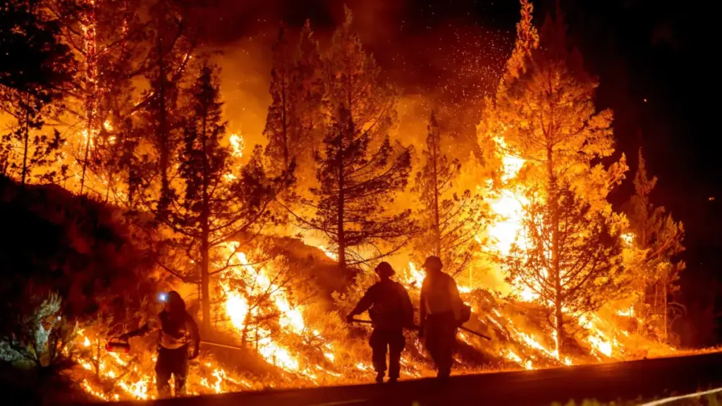
Driven by an exceptionally hot, dry summer and erratic wind patterns, the Grasshopper Fire has rapidly expanded into a multi-thousand-acre inferno. Sparked by a lightning strike on July 23, the blaze has consumed nearly 35,000 acres of dense forest, high-altitude timber, and fragile alpine ecosystems as of August 5. With containment lingering at a precarious 19 percent, an estimated 1,300 firefighters, smokejumpers, and emergency management personnel are locked in a relentless battle to halt the fire’s advance.
The catastrophe has forced sweeping closures across the Mount Hood region, a premier destination for outdoor recreation, winter sports, and historical tourism. Authorities have enacted mandatory "Go Now" evacuations for the Mt. Hood Meadows ski resort, placed the iconic, nearly 90-year-old Timberline Lodge under a Level 1 "Be Ready" advisory, and shut down more than 50 backcountry trails, including major segments of the regional trail network.
While no human lives or injuries have been reported—thanks to the swift, proactive evacuation of Forest Service personnel and resort staff—the psychological and physical toll on the local community is profound. The loss of Flag Point Lookout marks not only the destruction of a 102-year-old historical artifact, but a sobering reminder of the growing vulnerability of America’s public lands in an era of intensifying climate volatility.
Detailed Chronology of the Grasshopper Fire
To understand the rapid escalation of the Grasshopper Fire, one must trace its path from a remote lightning strike to a regional emergency that has fundamentally disrupted summer operations across Mount Hood.
Ignition and Early Growth (July 23 – July 30)
- July 23: A dry lightning storm passes over the Cascades, striking the rugged terrain east of Mount Hood. The initial spark smolders undetected in heavy timber and dry brush before catching the afternoon thermal drafts.
- July 24–30: Pushed by seasonal heatwaves and prolonged drought conditions, the fire begins an aggressive lateral expansion. Forest Service units, aided by aerial reconnaissance and remote-sensing satellite data, establish initial containment lines. However, inaccessible terrain, steep canyons, and dry fuels hamper ground crews, allowing the fire to steadily grow beyond initial containment estimates.
The Turning Point and Destruction of Flag Point (July 31)
- July 31: A critical meteorological shift occurs. Pushed by unusual easterly winds rather than the region’s standard westerly flows, the Grasshopper Fire surges rapidly toward high-elevation infrastructure. Recognizing the imminent danger, U.S. Forest Service officials successfully evacuate all personnel stationed at the Flag Point Fire Lookout. Hours later, the wall of flames overtakes the site. The 102-year-old timber and glass cabin, which had survived a century of lightning storms, heavy snowpacks, and regional fires, is completely consumed, leaving only charred foundations and twisted metal.
Evacuations and Regional Shutdown (August 1 – August 5)
- August 3: With the fire continuing its westward push, emergency management officials issue a Level 1 "Be Ready" evacuation notice for Timberline Lodge, urging staff and visitors to prepare for potential displacement.
- August 4 (Early Morning): Following a sudden surge driven by shifting winds, Mt. Hood Meadows ski resort receives a Level 3 "Go Now" evacuation order. Resort leadership and local sheriffs orchestrate a rapid, orderly evacuation of the facility. Concurrently, regional air quality plummets, prompting widespread closures of outdoor recreation hubs, including Skibowl near Government Camp.
- August 5: The fire officially crosses the 35,000-acre threshold. Nearly 1,300 personnel struggle to secure perimeter lines on the eastern and southern flanks. More than 50 trails, key segments of regional wilderness corridors, and critical transportation links such as Highway 35 remain locked down under emergency Forest Service closure orders stretching through December 31.
Supporting Context & Metrics
The sheer scale of the Grasshopper Fire cannot be measured by acreage alone; its impact ripples across the socio-economic, ecological, and recreational fabric of the Pacific Northwest.
Operational and Geographical Metrics
- Total Acreage Burned: ~35,000 acres (as of August 5, 2026).
- Containment Rate: 19%.
- Personnel Deployed: ~1,300 firefighters, safety officers, and logistical support personnel.
- Date of Ignition: July 23, 2026.
- Date of Flag Point Loss: July 31, 2026.
- Trails Closed: 50+ designated USFS trails, including the iconic 41-mile Timberline Trail loop.
Economic and Recreational Disruptions
Mount Hood is a year-round economic engine for northern Oregon, drawing hundreds of thousands of hikers, mountain bikers, climbers, and tourists. The sudden mid-summer shutdown has paralyzed local businesses:
- Mt. Hood Meadows: Located roughly 60 miles from Portland, the resort was forced to halt all summer operations, scenic chairlift rides, and alpine events during its peak operational window.
- Timberline Lodge: Built in 1938 as a Works Progress Administration (WPA) project and designated a National Historic Landmark, the lodge suspended its core hiking and mountain biking operations as smoke blanketed the southern slopes and evacuation warnings loomed.
- Skibowl: Operating near Government Camp, the year-round recreation hub was forced to shutter its doors entirely due to hazardous, unbreathable air quality indices.
Official Statements and Perspectives
Navigating the crisis requires a delicate balance between emergency response, resource allocation, and public transparency. Key leaders from the Mount Hood National Forest and local tourism infrastructure have provided critical insights into the strategy and aftermath of the disaster.
The Forest Service Perspective: Modern Detection vs. Historic Loss
Heather Ibsen, public affairs spokesperson for the Mount Hood National Forest, spoke directly with Outside regarding the loss of Flag Point and the broader strategy governing the forest’s defense.
Reflecting on the emotional weight of losing a century-old landmark, Ibsen acknowledged the community’s grief while contextualizing the technological redundancy of modern forest management:
"It’s been hot and dry this whole summer… The in-person fire lookouts are really valuable, but they’re not the only tool we have."
Ibsen noted that while structures like Flag Point hold immense historical and cultural value, contemporary wildfire detection relies on a sophisticated matrix of remote-sensing technologies:
- High-definition optical and infrared forest cameras.
- Real-time satellite heat-signature data.
- Aerial reconnaissance and thermal-imaging flights.
- Ground patrols conducted by mobile Forest Service units.
Consequently, Ibsen assured the public that the destruction of Flag Point does not leave an operational blind spot in the forest’s early-warning network.
Resort Leadership: The Meteorological Anomaly
Greg Pack, President of Mt. Hood Meadows, addressed local media outlet KPTV following the abrupt issuance of the Level 3 evacuation order. Pack explained that the resort’s vulnerability was exacerbated by a rare and treacherous meteorological reversal:
"Whelp, we hoped we wouldn’t have to post this, but here we are."
Typically, prevailing winds across Mount Hood flow from west to east, naturally pushing smoke, heat, and fire away from the primary resort infrastructure clustered on the mountain’s southern and eastern shoulders. However, days of sustained easterly wind patterns drove the Grasshopper Fire directly against established natural firebreaks and straight toward the Meadows boundary, forcing the immediate evacuation order.
Future Outlook: Damage Assessment, Ecological Recovery, and Reopening
As firefighting crews continue their grueling work on the front lines, land managers are already casting their gaze toward the long-term horizon. The path to ecological recovery and infrastructure restoration on Mount Hood will be measured in years, not months.
The Scientific and Engineering Assessment Process
Once the Grasshopper Fire is fully contained and active thermal threats subside, the recovery phase transitions from tactical firefighting to scientific triage. According to MHNF officials, specialized interdisciplinary teams will deploy into the burn scar:
- Resource Specialists and Soil Scientists: These professionals will evaluate the burn severity across various strata, assessing soil hydrophobic properties (water repellency), erosion risks, and potential threats to downstream watersheds and aquatic habitats.
- Geologists and Hydrologists: Teams will examine slope stability, mapping out areas highly vulnerable to post-fire debris flows, mudslides, and flash flooding during autumn rains and winter snowmelts.
- Recreation Infrastructure Engineers: Inspectors will systematically inventory damaged bridges, boardwalks, signage, trailhead kiosks, and outbuildings to formulate accurate cost estimates and funding requests.
Phased Reopening Strategy
Reopening the mountain will not happen overnight, nor will it occur uniformly. Ibsen emphasized that wilderness management principles differ vastly from developed recreation zones:
- Wilderness Areas: Stricter federal guidelines govern designated wilderness tracts (such as portions of the Pacific Crest Trail corridor and surrounding federal wilderness), where the restoration of natural processes takes precedence over rapid structural repair.
- Developed Corridors: High-traffic hubs, campgrounds, and resort perimeters will see prioritized interventions. In some cases, the Forest Service may elect to reopen public access to specific geographical zones for safety and recreation before all ancillary amenities, restrooms, or damaged trail structures have been fully rebuilt.
"We want to open up areas to public access as soon as it’s safe to do so," Ibsen stated. "How we manage wilderness areas is very different from how we might manage something that is very developed, around a busy campground on a lake."
Essential Guidance for Visitors and Travelers
For residents, travelers, and outdoor enthusiasts planning to visit the Mount Hood corridor or broader Oregon mountain passes in the coming weeks, extreme caution is mandatory:
- Verify Before You Drive: Check real-time road conditions, emergency closures, and highway restrictions (such as closures along Highway 35) via the Oregon Department of Transportation (ODOT).
- Monitor Evacuation Zones: Consult local county sheriff office evacuation maps and active Forest Service closure orders daily, as fire behavior and wind vectors can shift dramatically without warning.
- Check Air Quality: Real-time particulate data and smoke forecasts are accessible via platforms like AirNow to safeguard respiratory health before heading into outdoor environments across the Pacific Northwest.